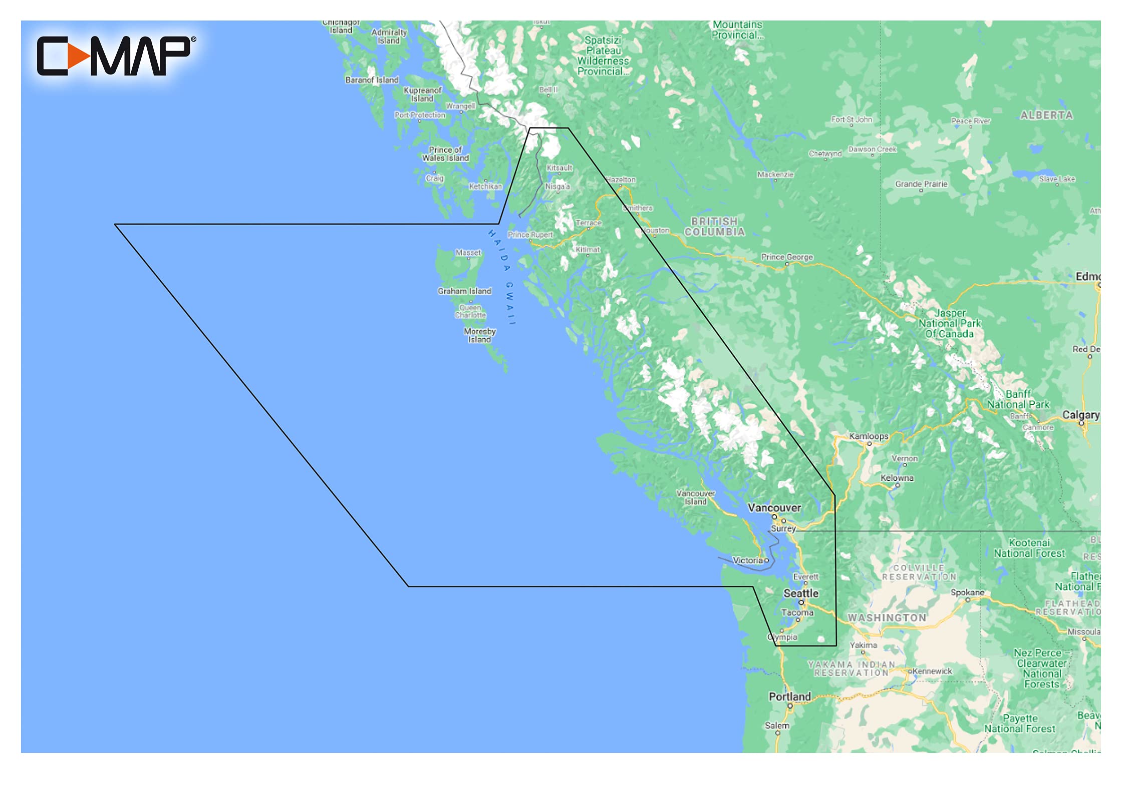
C Map Reveal Coastal British Columbia And Puget Sound, Map Card For Marine Gps Navigation
No reviews
$154.32
Regular price
$220.46
-30%
Vendor: C-Map
Type: Marine Navigation
Sku: WBEEAB08YRZXC2R
Availability: In Stock
Couldn't load pickup availability
Guarantee safe checkout
Processing time : 1-3 days
US Orders Ships in : 3-5 days
International Orders Ships in : 8-12 days
15-days return on defective items
Shipping information
Our Shipping Promise
At Electroeshop, we understand that your pet supplies are important. That's why we take extra care with every package we send. All orders are shipped in double-boxes with full insurance for additional protection, ensuring your items arrive safely.
Processing & Shipping Timeline
Processing Time: Orders are processed within 1-3 business days
Domestic Delivery: Typically 3-5 business days
Please note that delivery times are estimates and may vary based on your location, weather conditions, or other unforeseen circumstances.
Shipping Destinations
Electroeshop currently only ships to the United States.
Shipping Costs
We are pleased to offer free standard shipping on all orders within the United States.
Discreet Packaging
We respect your privacy. All Electroeshop packages are shipped with complete discreet packaging. The product name, description, sender's name, and any information that hints about the contents are encrypted. Your package will arrive without any indication of what's inside, ensuring your purchase remains confidential.
Signature Requirements
Important Note: All orders valued above $250 will require a signature upon delivery for your protection.
Order Tracking
Once your order ships, you'll receive a tracking number via email so you can monitor your shipment's progress every step of the way.
Lost or Delayed Shipments
If your package is lost or significantly delayed, please contact our support team immediately, and we will assist you in resolving the issue.
Additional Security Measures
For your protection, we may contact you for additional order verification of the payment method on certain orders.
Questions or Concerns?
For details on returns and refunds, please refer to our Return Policy page. For any questions about shipping or delivery, please contact our customer service team at support@Electroeshop.com.
Cruising, Fishing Or Sailing, C-Map Reveal Coastal Charts Offer The Very Best Of C-Map. With Shaded Relief, Including Game-Changing Reveal Seafloor Imagery, Aerial Photography, Satellite Overlay And Dynamic Raster Chart Presentation Added To The Core C-Map Features Found In Discover - Full-Featured Vector Charts, With Custom Depth Shading, Tides & Currents And Subscription-Free Easy Routing. It Also Includes The Very Best Of C-Map High-Res Bathy, Including Integrated Genesis Data. Purchase Includes A Full 12 Months Of Free Online Updates. Compatible With Lowrance, Simrad & B&G Chartplotters. Shaded Relief - Bring The World Around You To Life, With 3D Rendered Land And Underwater Elevation - Including Areas Of Ultra-High-Res Bathy Seafloor Imagery, Previously Only Available In Max-N+ Reveal - A Game-Changer For Anglers. Full-Featured Vector Charts - Making Navigation Easy By Giving You Accurate, Up-To-Date Vector Chart Detail Derive From Official Hydrographic Office Information. High-Res Bathy - Helps You Identify Shallow Areas, Drop-Offs, Ledges, Holes Or Humps. Now Includes Compiled And Quality-Controlled Genesis Detail As Part Of Singular Hrb Layer. Custom Depth Shading - Set A Clear Safety Depth, Maintain A Paper-Like View Or Create Your Own Custom Shading. Dynamic Raster Charts - Providing The Traditional Chart Look And Feel, Coupled With Easy Access To All Objects On The Chart. Easy Routing - Helps You Automatically Plot The Shortest, Safest Route Based On Detailed Chart Data And Your Personalized Vessel Information. Aerial Photography - A Collection Of Thousands Of Photos Of Marinas, Harbors, Inlets And Other Notable Navigational Features Included To Offer An Additional Level Of Detail. Satellite Overlay - Satellite Imagery Gives Information About The Surroundings When You Find Yourself In An Unfamiliar Place. Tides & Currents - Shows Projections Of Water Level And Direction Of Tides To Help Plan Your Day Out, Cruising, Angling Or Sailing. Detailed Marina Port Plans - Docking In An Unfamiliar Port Is No Problem When You Have Precise Layouts Of Thousands Of Marinas, Including Slip Spaces, Restricted Areas And Other Valuable Navigation Information. Harbor & Approach Details - Unprecedented Level Of Detail. Approach Any Harbor And Inlet With Confidence. The Perfect Conclusion To A Long Voyage, Sailing Adventure Or An Exciting Day Of Fishing. Online Updates - Keep Your Chart Up To Date, With 12 Months Free Online Updates.
⚠️ WARNING (California Proposition 65): This product may contain chemicals known to the State of California to cause cancer, birth defects, or other reproductive harm. For more information, please visit www.P65Warnings.ca.gov.
<div class="dynamic-checkout__content" id="dynamic-checkout-cart" data-shopify="dynamic-checkout-cart"> <shopify-accelerated-checkout-cart wallet-configs="[{"name":"shop_pay","wallet_params":{"shopId":71498399780,"merchantName":"Electroeshop","personalized":true}},{"name":"amazon_pay","wallet_params":{"checkoutLanguage":"en_US","ledgerCurrency":"USD","placement":"Cart","sandbox":false,"merchantId":"A1D97EELABIYRS","productType":"PayAndShip","design":"C0002"}},{"name":"paypal","wallet_params":{"shopId":71498399780,"countryCode":"US","merchantName":"Electroeshop","phoneRequired":true,"companyRequired":false,"shippingType":"shipping","shopifyPaymentsEnabled":true,"hasManagedSellingPlanState":false,"requiresBillingAgreement":false,"merchantId":"CTDG3UHVZNL4L","sdkUrl":"https://www.paypal.com/sdk/js?components=buttons\u0026commit=false\u0026currency=USD\u0026locale=en_US\u0026client-id=AbasDhzlU0HbpiStJiN1KRJ_cNJJ7xYBip7JJoMO0GQpLi8ePNgdbLXkC7_KMeyTg8tnAKW4WKrh9qmf\u0026merchant-id=CTDG3UHVZNL4L\u0026intent=authorize"}}]" access-token="ab31e70b5cc21a1ceee088fbb76625d8" buyer-country="US" buyer-locale="en" buyer-currency="USD" shop-id="71498399780" cart-id="99d29c379dbadbccf0a4801b06aa969c" > <div class="wallet-button-wrapper"> <ul class='wallet-cart-grid wallet-cart-grid--skeleton' role="list" data-shopify-buttoncontainer="true"> <li data-testid='grid-cell' class='wallet-cart-button-container'><div class='wallet-cart-button wallet-cart-button__skeleton' role='button' disabled aria-hidden='true'> </div></li><li data-testid='grid-cell' class='wallet-cart-button-container'><div class='wallet-cart-button wallet-cart-button__skeleton' role='button' disabled aria-hidden='true'> </div></li><li data-testid='grid-cell' class='wallet-cart-button-container'><div class='wallet-cart-button wallet-cart-button__skeleton' role='button' disabled aria-hidden='true'> </div></li> </ul> </div> </shopify-accelerated-checkout-cart> <small id="shopify-buyer-consent" class="hidden" aria-hidden="true" data-consent-type="subscription"> One or more of the items in your cart is a recurring or deferred purchase. By continuing, I agree to the <span id="shopify-subscription-policy-button">cancellation policy</span> and authorize you to charge my payment method at the prices, frequency and dates listed on this page until my order is fulfilled or I cancel, if permitted. </small> </div>